3D Models & 3D GIS
Navigate the 3D-models by selecting a part of the insula. For best possible performance and compatibility, open the link with Google Chrome. (Try to reload the page if the 3D-model does not appear.)
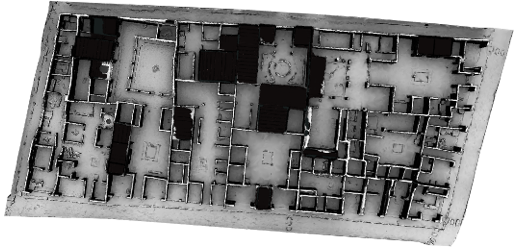
Navigate the 3D-model of the complete insula.
The technology permitting on line models equipped with a measuring tool was developed by the ISTI for the Swedish Pompeii Project.
The technology by which the models could be imported into the GIS-system was developed at Lund University. It has opened for various new analytic possibilities. As these applications require too large computer capacity to be manageable on line, this page has to content itself with the following films in its aim to give a hint about the potential of the 3D GIS.
Screen recordings of the acquired and analyzed data is presented at the YouTube Digital Archaeology Lab
The YouTube channel of the Digital Archaeology Lab
3D-model of the entire insula
Navigate the 3D-model of the complete insula.
Campaigns
In two brief campaigns, 2011-2012, and a brief return with a drown, one morning in Mai 2015, the entire insula V 1 was laser scanned. This acquisition resulted from collaboration between the Humanities Laboratory (HUMLab), the Institute of Archaeology and Ancient History & the Digital Arkeologi Labotratoriet (DARKLab) at Lund University and the Istituto di Scienza e Tecnologie dell’Informazione "A. Faedo" (ISTI) at (CNR) Pisa. Links to some of the applications in which the processed data has been put to use are presented below.The technology permitting on line models equipped with a measuring tool was developed by the ISTI for the Swedish Pompeii Project.
The technology by which the models could be imported into the GIS-system was developed at Lund University. It has opened for various new analytic possibilities. As these applications require too large computer capacity to be manageable on line, this page has to content itself with the following films in its aim to give a hint about the potential of the 3D GIS.
![]()
3D GIS
Screen recordings of the acquired and analyzed data is presented at the YouTube Digital Archaeology Lab
V 1,26 House of Caecilius Iucundus - South House
3D GIS for Cultural Heritage Restoration, part 1
3D GIS for Cultural Heritage Restoration, part 2
3D GIS for Cultural Heritage Restoration, part 3
The YouTube channel of the Digital Archaeology Lab